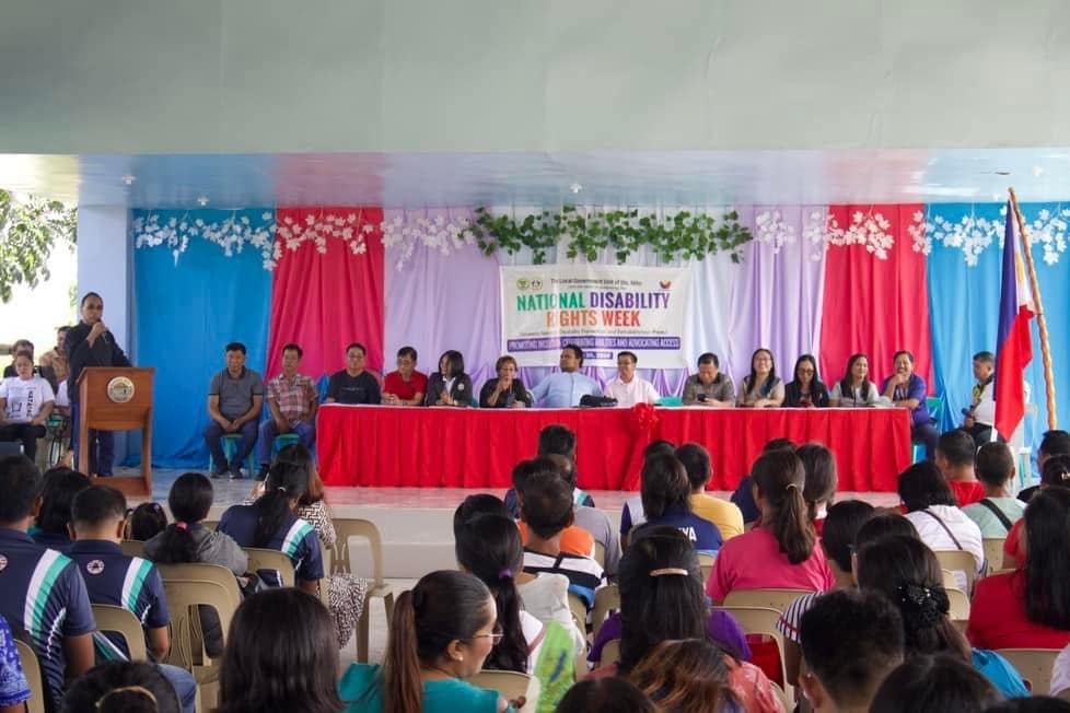
The Municipal Social Welfare and Development Office joined the national government in the celebration of the National Disability Rights Week with the theme “Promoting Inclusion: Celebrating Abilities and Advocating Access”.
This is pursuant with Proclamation No. 597 by President Ferdinand R. Marcos Jr. declaring July 17 to 23 of every year as “National Disability Rights Week” to promote a rights-based approach in raising awareness on the plight of persons with disabilities.
Municipal Vice Mayor AV Pagurayan expressed his warmest love and support to the PWDs. He emphasized that PWDs is one of the vulnerable groups closest to his heart. He also inspired them to keep moving forward and believe that they are capable of achieving incredible things. He also recognized their strength and resilience.
Ms. Amelia Decena, PWD Right Advocate/ NAPC Regional Office No. 02 Representative, discussed the PWD Related Laws. LGUs Programs and Services for PWDs are also explained by Mr. Romel Tejada, MSWDO/ PDAO Designate.
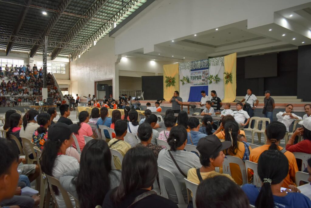
July 29, 2024 , the Department of Labor and Employment (DOLE) collaborated with the Local Government Unit (LGU) of Sto. Niño to conduct TUPAD (Tulong Panghanapbuhay sa Ating Disadvantaged/Displaced Workers) Orientation and Profiling program. Led by Mayor Atty. Vicente G. Pagurayan and Vice Mayor Andrew Vincent R. Pagurayan, the initiative aimed to provide opportunities for disadvantaged and displaced workers in the community.
Thanks to the generous support from Congresswoman Baby Aline Vargas-Alfonso and Senator Mark Villar, a total of 810 beneficiaries were sponsored by Congresswoman Vargas-Alfonso, while Senator Villar supported 199 beneficiaries. This joint effort highlights the dedication of public officials at both national and local levels to uplift and empower those in need in the community.
The TUPAD program offers temporary employment to the beneficiaries to enhance their livelihood and financial stability. Through such initiatives, the LGU of Sto. Niño and DOLE are collaborating to build a more inclusive and prosperous society for all residents.
Mayor Pagurayan expressed gratitude to Congresswoman Baby Aline Vargas-Alfonso, Senator Mark Villar, and all program supporters for their valuable contributions to the community’s development. He stressed the importance of cooperation and teamwork in addressing the needs of disadvantaged workers and ensuring no one is left behind.
Vice Mayor Andrew Vincent R. Pagurayan praised the beneficiaries for their dedication and hard work in embracing the opportunities provided by the TUPAD program. He emphasized the significance of programs like TUPAD in promoting dignity, self-reliance, and empowerment among disadvantaged individuals.
The success of the TUPAD Orientation and Profiling program demonstrates the positive impact that partnerships between government agencies, elected officials, and community leaders can have on those in need. As Sto. Niño strives for progress and inclusivity; these collaborative efforts showcase the unity and support within the community.
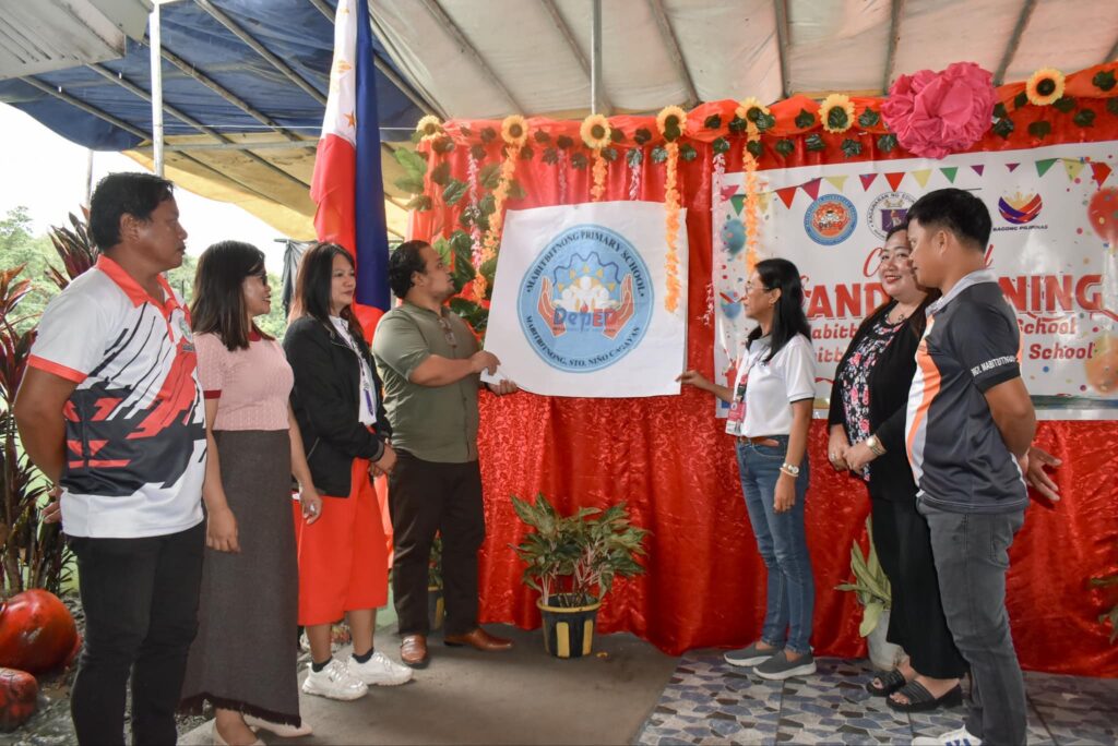
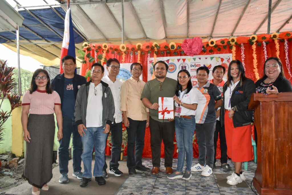
The Department of Education- Santo Niño District headed by Maam Erna Angeles conducted the Ceremonial Opening of Mabitbitnong Primary School to Mabitbitnong Elementary School.
The conversion of Mabitbitnong Primary School to Mabitbitnong Elementary School was made possible through the initiative of Dr. Genalyn Oarde in collaboration with different stakeholders to include the Municipal Government.
Present during the said program is Municipal Vice Mayor AV Roxas Pagurayan who pronounced that the Municipal Government will continue to provide support to the Department of Education and to prioritize projects related to education.
Maam Erna Angeles, Public School District Supervisor also also expressed her warmest gratitude to the Municipal Government for their continous support to the DepEd programs and activities.
One of the intervention of the LGU is the enactment of an Ordinance Renaming Mabitbitnong Primary School to Mabitbitnong Elementary School by the Sangguniang Bayan which is one of the documentary requirements for the application for conversion.
Valid for broadcast until the next bulletin at 5:00 PM today.
SEVERE TROPICAL STORM “CARINA” CONTINUES TO STEADILY INTENSIFY AS IT MOVES NORTHWESTWARD OVER THE PHILIPPINE SEA.
• Location of Center (10:00 AM)
The center of Severe Tropical Storm CARINA was estimated based on all available data at 355 km East of Tuguegarao City, Cagayan (17.4°N, 125.1°E)
• Intensity
Maximum sustained winds of 110 km/h near the center, gustiness of up to 135 km/h, and central pressure of 985 hPa
• Present Movement
Northwestward at 15km/h
• Extent of Tropical Cyclone Winds
Strong to storm-force winds extend outwards up to 340 km from the center
TROPICAL CYCLONE WIND SIGNALS (TCWS) IN EFFECT
TCWS No. 1
○ Wind threat: Strong winds
○ Warning lead time: 36 hours
○ Range of wind speeds: 39 to 61 km/h (Beaufort 6 to 7)
○ Potential impacts of winds: Minimal to minor threat to life and property
LUZON:
Batanes, the eastern portion of mainland Cagayan (Santa Ana, Gattaran, Baggao, Peñablanca, Lal-Lo, Gonzaga) including the eastern portion of Babuyan Islands (Camiguin Is., Babuyan Is.), and the northeastern portion of Isabela (Divilacan, Palanan, Maconacon)
OTHER HAZARDS AFFECTING LAND AREAS
Heavy Rainfall Outlook
Forecast accumulated rainfall: Today to Tomorrow noon (23 July)
• 100-200 mm: The extreme northeastern portion of mainland Cagayan
• 50-100 mm: Babuyan Islands and the eastern portions of mainland Cagayan and Isabela
Forecast rainfall are generally higher in elevated or mountainous areas. Under these conditions, flooding and rain-induced landslides are possible especially in areas that are highly or very highly susceptible to these hazards as identified in official hazard maps and in localities that experienced considerable amounts of rainfall for the past several days.
Furthermore, the Southwest Monsoon enhanced by CARINA will bring moderate to intense rainfall over various localities in the western portion of Luzon tonight through Wednesday. For more information, refer to Weather Advisory No. 25 issued at 11:00 AM today.
Severe Winds
Minimal to minor impacts due to strong winds may be experienced within any of the localities where Wind Signal No. 1 is hoisted.
The Southwest Monsoon enhanced by CARINA will also bring strong to gale-force gusts over the following areas (especially in coastal and upland areas exposed to winds):
• Today: Zambales, Bataan, Aurora, MIMAROPA, Bicol Region, Western Visayas, Northern Samar, and the northern portion of Samar.
• Tomorrow: Ilocos Region, Zambales, Bataan, Aurora, Metro Manila, CALABARZON, MIMAROPA, Bicol Region, and Visayas
• Wednesday: Ilocos Region, Abra, Benguet, Apayao, Nueva Vizcaya, Quirino, Isabela, Central Luzon, Metro Manila, CALABARZON, MIMAROPA, Bicol Region, and Visayas.
HAZARDS AFFECTING COASTAL WATERS
In the next 24 hours, CARINA and the enhanced Southwest Monsoon will bring moderate to rough seas over the northern and eastern seaboards of Luzon (2.0 to 3.5 m) and western seaboards of Central and Southern Luzon, and Western Visayas (1.5 to 3.0 m). Mariners of small seacrafts, including all types of motorbancas, are advised not to venture out to sea under these conditions, especially if inexperienced or operating ill-equipped vessels.
Moderate seas are also expected over the eastern seaboards of Visayas and Mindanao (1.5 to 2.0 m). Mariners of motorbancas and similarly-sized vessels are advised to take precautionary measures while venturing out to sea and, if possible, avoid navigating under these conditions.
TRACK AND INTENSITY OUTLOOK
• Over the Philippine Sea, CARINA is forecast to move generally northward from today until tomorrow (23 July) while gradually accelerating before turning northwestward for the remainder of the forecast period. On the track forecast, CARINA will remain far from the Philippine landmass and exit the Philippine Area of Responsibility on Wednesday evening or Thursday early morning (25 July). The track forecast also shows CARINA passing near or over the southern islands of the Ryukyu archipelago prior to leaving the PAR region and passing close to northern Taiwan after exiting the PAR. From Thursday onwards, CARINA will move over the East China Sea towards southeastern China.
• CARINA is forecast to steadily intensify over the next four days due to favorable environment. It is forecast to reach typhoon category within 12 hours. Rapid intensification within the forecast period is likely.
Considering these developments, the public and disaster risk reduction and management offices concerned are advised to take all necessary measures to protect life and property. Persons living in areas identified to be highly or very highly susceptible to these hazards are advised to follow evacuation and other instructions from local officials. For heavy rainfall warnings, thunderstorm/rainfall advisories, and other severe weather information specific to your area, please monitor products issued by your local PAGASA Regional Services Division.
The next tropical cyclone bulletin will be issued at 5:00 PM today.
The center of Severe Tropical Storm CARINA was estimated based on all available data at 420 km East of Tuguegarao City, Cagayan (17.2°N, 125.7°E)
𝐈𝐧𝐭𝐞𝐧𝐬𝐢𝐭𝐲:
Maximum sustained winds of 100 km/h near the center, gustiness of up to 125 km/h, and central pressure of 990 hPa
𝐏𝐫𝐞𝐬𝐞𝐧𝐭 𝐌𝐨𝐯𝐞𝐦𝐞𝐧𝐭:
North Northwestward slowly
𝐄𝐱𝐭𝐞𝐧𝐭 𝐨𝐟 𝐓𝐫𝐨𝐩𝐢𝐜𝐚𝐥 𝐂𝐲𝐜𝐥𝐨𝐧𝐞 𝐖𝐢𝐧𝐝𝐬:
Strong to storm-force winds extend outwards up to 360 km from the center
𝐓𝐑𝐎𝐏𝐈𝐂𝐀𝐋 𝐂𝐘𝐂𝐋𝐎𝐍𝐄 𝐖𝐈𝐍𝐃 𝐒𝐈𝐆𝐍𝐀𝐋𝐒 (𝐓𝐂𝐖𝐒) 𝐈𝐍 𝐄𝐅𝐅𝐄𝐂𝐓
𝐓𝐂𝐖𝐒 𝐍𝐨. 𝟏 (Wind threat: Strong winds)
𝐖𝐚𝐫𝐧𝐢𝐧𝐠 𝐥𝐞𝐚𝐝 𝐭𝐢𝐦𝐞: 36 hours
𝐑𝐚𝐧𝐠𝐞 𝐨𝐟 𝐰𝐢𝐧𝐝 𝐬𝐩𝐞𝐞𝐝𝐬: 39 to 61 km/h (Beaufort 6 to 7)
𝐏𝐨𝐭𝐞𝐧𝐭𝐢𝐚𝐥 𝐢𝐦𝐩𝐚𝐜𝐭𝐬 𝐨𝐟 𝐰𝐢𝐧𝐝𝐬: Minimal to minor threat to life and property
𝐋𝐮𝐳𝐨𝐧
The eastern portion of mainland Cagayan (Santa Ana, Gattaran, Baggao, Peñablanca, Lal-Lo, Gonzaga) and the northeastern portion of Isabela (Divilacan, Palanan, Maconacon)
𝐎𝐓𝐇𝐄𝐑 𝐇𝐀𝐙𝐀𝐑𝐃𝐒 𝐀𝐅𝐅𝐄𝐂𝐓𝐈𝐍𝐆 𝐋𝐀𝐍𝐃 𝐀𝐑𝐄𝐀𝐒
𝐇𝐞𝐚𝐯𝐲 𝐑𝐚𝐢𝐧𝐟𝐚𝐥𝐥 𝐎𝐮𝐭𝐥𝐨𝐨𝐤
Forecast accumulated rainfall: Today
• 100-200 mm: The extreme northeastern portion of mainland Cagayan
• 50-100 mm: Babuyan Islands and the eastern portions of mainland Cagayan and Isabela
Forecast accumulated rainfall: Tomorrow (23 July)
• 100-200 mm: Batanes
• 50-100 mm: Babuyan Islands and the northeastern portion of mainland Cagayan
Forecast rainfall are generally higher in elevated or mountainous areas. Under these conditions, flooding and rain-induced landslides are possible especially in areas that are highly or very highly susceptible to these hazards as identified in official hazard maps and in localities that experienced considerable amounts of rainfall for the past several days.
Furthermore, the Southwest Monsoon enhanced by CARINA will bring moderate to intense rainfall over various localities in the western portion of Luzon tonight through Wednesday. For more information, refer to Weather Advisory No. 24 issued at 11:00 PM yesterday.
𝐒𝐞𝐯𝐞𝐫𝐞 𝐖𝐢𝐧𝐝𝐬
Minimal to minor impacts due to strong winds may be experienced within any of the localities where Wind Signal No. 1 is hoisted.
The Southwest Monsoon enhanced by CARINA will also bring strong to gale-force gusts over the following areas (especially in coastal and upland areas exposed to winds):
• Today: MIMAROPA, Bicol Region, Western Visayas, Northern Samar, and the northern portion of Samar.
• Tomorrow: Zambales, Bataan, Aurora, Metro Manila, CALABARZON, MIMAROPA, Bicol Region, and Visayas
• Wednesday: Ilocos Region, Abra, Benguet, Nueva Vizcaya, Quirino, Central Luzon, Metro Manila, CALABARZON, MIMAROPA, Bicol Region, and Visayas.
𝐇𝐀𝐙𝐀𝐑𝐃𝐒 𝐀𝐅𝐅𝐄𝐂𝐓𝐈𝐍𝐆 𝐂𝐎𝐀𝐒𝐓𝐀𝐋 𝐖𝐀𝐓𝐄𝐑𝐒
In the next 24 hours, CARINA and the enhanced Southwest Monsoon will bring moderate to rough seas over the northern and eastern seaboards of Northern Luzon (1.5 to 3.0 m). Mariners of small seacrafts, including all types of motorbancas, are advised not to venture out to sea under these conditions, especially if inexperienced or operating ill-equipped vessels.
Moderate seas are also expected over the seaboards of Central and Southern Luzon (1.5 to 2.5 m) and the eastern seaboards of Visayas and Mindanao (1.5 to 2.0 m). Mariners of motorbancas and similarly-sized vessels are advised to take precautionary measures while venturing out to sea and, if possible, avoid navigating under these conditions.
𝐓𝐑𝐀𝐂𝐊 𝐀𝐍𝐃 𝐈𝐍𝐓𝐄𝐍𝐒𝐈𝐓𝐘 𝐎𝐔𝐓𝐋𝐎𝐎𝐊
• Over the Philippine Sea, CARINA is forecast to move generally north northwestward to northward until mid-Wednesday (24 July) while gradually accelerating before turning northwestward for the remainder of the forecast period. On the track forecast, CARINA will remain far from the Philippine landmass and exit the Philippine Area of Responsibility on Wednesday evening or Thursday early morning (25 July). The track forecast also shows CARINA passing near or over the southern islands of the Ryukyu archipelago prior to leaving the PAR region and passing close to northern Taiwan after exiting the PAR. From Thursday onwards, CARINA will move over the East China Sea towards southeastern China.
• CARINA is forecast to steadily intensify over the next four days due to favorable environment. It is forecast to reach typhoon category within 24 hours. Rapid intensification within the forecast period is likely.
Considering these developments, the public and disaster risk reduction and management offices concerned are advised to take all necessary measures to protect life and property. Persons living in areas identified to be highly or very highly susceptible to these hazards are advised to follow evacuation and other instructions from local officials. For heavy rainfall warnings, thunderstorm/rainfall advisories, and other severe weather information specific to your area, please monitor products issued by your local PAGASA Regional Services Division.
The next tropical cyclone bulletin will be issued at 11:00 AM today.
Sto. Niño, July 19, 2024 – The LYDO Sto. Niño in partnership with SNCYDC, SK Federation, SK Council, YORP, and Rang-Ay successfully organized a vibrant Pride Celebration with the theme “Sto. Niño Youth: Champions of Social Equity and Inclusivity.”
The event featured an array of inspiring speakers including Vice Mayor Andrew Vincent R. Pagurayan, who graced the occasion with his Welcome Remarks and shared an Inspirational Message. Vice Mayor Pagurayan touched hearts by expressing pride in his daughter and son who are part of the LGBTQIA+ community. He also conveyed his belief in the power of kindness and generosity through his favorite mantra, “Pay It Forward.”
Additionally, the celebration benefited from the presence of Mr. Jose Aureo C. Camacam, JD, DPA, from CSU Carig who delivered an enlightening presentation on Laws pertaining to vulnerable sectors. His insightful knowledge shed light on important legal frameworks and protections for marginalized communities.
The Pride Celebration in Sto. Niño brought together individuals from diverse backgrounds to promote a culture of acceptance, equality, and respect for all. Through partnerships with various organizations and the unwavering support of community leaders, the event served as a catalyst for fostering a more inclusive society.
The Basic Incident Command System Training Course was held at Las Palmas De San Jose Leisure Club,Tuguegarao City on July 17–19, 2024.
The 3-day training consisting of 8 modules, was facilitated by Jaye M. Cabauatan OCD -R02,Francisco R. Estavillo CDRRMO Ilagan City,Junalyn D. Addatu BFP-R02 and Jane Airien T. Reyno OCD- R02 through classroom management, conduct activities, and sharing of experiences.
This training was attended by the LGU Department heads, officials from DILG, BFP,PNP, staff from different offices, and other members of the MDRRM council, including Engr. Isabelito Abaya, MDRRMO 2.
The goal of this training is to equip the participants with the knowledge, abilities, and mindset necessary to apply the fundamental ideas and principles of ICS in any kind of emergency.
Hon. Congresswoman Baby Aline Vargas- Alfonso, Representative of the Second District of Cagayan in cooperation with the Department of Social Welfare and Development Office- Regional Field Office No. 02 (DSWD-RFO2) led the distribution of educational assistance to college students.
The said Educational Assistance Program is a priority project of the Office of the Congresswoman Baby Aline Vargas- Alfonso in partnership with Speaker Ferdinand Martin Romualdez, Senator Grace Poe, Congressman Allan U. Ty and the DSWD- Regional Office No. 02.
Also present during the activity were BM Randy Ursulum, BM Archie Layus, BM Alniñoson Kevin Timbas, Vice Mayor Andrew Vincent R. Pagurayan and Sangguniang Bayan Members.
Municipal Vice Mayor AV Roxas Pagurayan presided over the Executive Committee Meeting today.
The said meeting was attended by the different department heads who presented the accomplishments and updates of their respective offices.
One of the most important updates is the pronouncement of the MLGOO that the municipality of Santo Niño was endorsed for SGLG National Validation after having been validated by the Regional Assessment Team.
Municipal Vice Mayor AV Roxas Pagurayan presided the 2nd Quarter LCPC, LCAT-VAWC, LAC Joint Meeting.
MLGOO Jasmin Balisi discussed the Functionality Assessment Tool on CFLGA, LCPC and LCAT-VAWC. Meanwhile, MSWDO Romel Tejada also presented the 2025 Work and Financial Plan for Children and the activities to be undertaken in celebration of the Children’s Month.
Moreover, Ms. Marilet Luczon, Municipal Link, also presented the Local Transition Plan of 4Ps.